
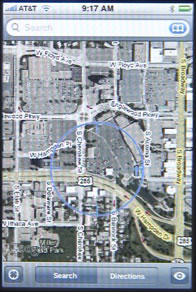
The iPhone Maps Application is allows you to view and search Google Maps. It also lets you see traffic reports in some cities, satellite views, and will give you directions from one location to another.
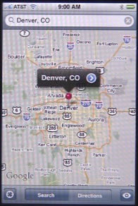
The main screen for Maps has a search field at the top and a few buttons at the bottom. Press the search field to bring up the keyboard. Then enter a location. You can enter a specific address, a zip code, the name of a city and state, or any search term to allow Google Maps to take its best guess.
Moving around the maps is done by pressing and dragging on your screen. You can zoom in by pinching the screen, and zoom out with the opposite gesture.
To get directions, press the Directions button at the bottom of the screen. You will now have two search fields at the top. Enter something in each field. You can use the squiggly button at the left to swap the fields.
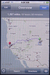
You can then press the Edit button to change the start or end locations, or use the Start button to see the first step in following the directions. Arrows will then replace the Start button and allow you to go through the directions step-by-step.
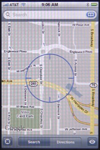
The iPhone can also find your current location with varying degrees of accuracy. Press the bulls-eye button at the lower left.
You can enable more Maps features by pressing the eye button at the bottom right. This brings up more options, such at the ability to drop a pin in the map at the current location, and to turn on traffic reports. You can also switch from map view to Satellite image view, or use a hybrid of map and imagery. The List view can be used when you are getting directions and simply wish to see a list of all the of the steps on one screen.
The traffic reports show up as green, red and yellow lines, usually on interstate highways in major cities. You may have to zoom out quite a distance to see them.
The Satellite and Hybrid views will show satellite pictures of the area. Different areas may have different quality and levels of depth.

great write-up. Had no idea Maps was in iPhone and that it was so powerful and helpful. gotta get one!
to bring back the maps-app back on home screen. go to
settings>general>reset>reset home screen layout.
it will be back. you dont have to restore anything.
Thank you so much for posting how to bring back the maps-app. It worked like a charm!
It worked! My Map and GPS is back! Thank you so much!
Thanks so much!!!
Thank you! And I didn't delete my other new Apps!!!
Hi
I found this article very helpful. My understanding is that the Map Application uses a combination of wi-fi, local masts and GPS. However, I often encounter blackspots where I can imagine there is unlkely to be wi-fi or local masts but I would expect satellite contact but the Map App does not work - any idea why blackspots should be experienced when outside buildings and GPS should be available? I have the iPhone 3GS.
Regards
Dave Wilshaw
I know the 3G chip is needed to get GPS signals. Any chance you have turned off the 3G chip (Airplane mode or something?)
The Maps app disappeared on my iPhone. How do I get it back?
The Maps app is one of the default ones -- there should be no way to delete it. I would back up in iTunes, then reset and restore.
The same thing happened to me!!!!!
Mine has disappeared as well - did anyone get it back yet and if so how?
Just for info - I reset and restored the I-phone. Maps did not come back! ........ But the all the apps I bought are gone :-(
Do you have your apps on your Mac (in iTunes)? If so, then just sync to get them back on your phone.
But if you restored and Maps is still missing, then I would go to the Genius Bar and have them take a look.
Go to Settings, go to General, Go to Reset. Go to Reset Home Screen Layout.
It should then reappear.
Maps is a wonderfully designed auto intelligent device that is one of best tools on iPhone. However, I was in the true forrest not near the city or wiFi and the GPS was indicating it was not 'working (as it is referred to) with space transmitters, what I thought was data received from GPS satellites. So, in open clear sky view country why did I not get any navigation function based on the warning of "weak GPS, (satellite) signal" yet, my hand help Garmin worked fine? Is this an issue with the iPhone hardware or software?
A couple of things. First, you can't use the Maps app way from a connection. It downloads all maps on the fly, so it just wont work. But there are some apps made for your situation that will work. See http://ngadventure.typepad.com/blog/2010/04/best-iphone-mapping-apps.html
Second, note that GPS uses wifi signals, cell towers and GPS satellites. The first two are fast, the last is slow. So if you are used to quick GPS readings in town, it is because wifi and towers are providing the data. Out in the wilderness it will take longer.
And, of course, you must have an iPhone 3G, 3GS or 4. The original iPhone didn't have the ability to access GPS satellite signals.
Current location is lock and able to find actual current location
Maps application on my iPhone 3gs could find the current location. How can I fix this problem?
Do you mean the GPS doesn't seem to work? You'll need to have someone take a look at it. Visit the Apple Store or call Apple.
On the maps icon it has a picture of the I-280 Actual the actual address I've been trying to find it out if curiosity :)
Sorry with my comment above I was wonderig if anyone knew wat the address was??
You mean the icon for the Maps app on the iPhone? That icon shows the location: 1 Infinite Loop, Cupertino, CA. If you don't know what is at 1 Infinite Loop, Cupertino, CA, then type it into Google Maps and see.
The maps on iphone4 does not talk tO me while I drive like my droid. I cannot be looking at the stupId phone while I drive and that makes me mad.
How do you keep your phone from falling asleep when using it for GPS directions...very frustrating to keep having to wake it up every couple of minutes.
Settings. General. Auto-Lock.
ok.. this may sound abit weird.. but how the heck do u zoom out on the gps... i kno to zoom in u just double tap , but i cannot figure out how to zoom back out.. there is not + or - .. pls can someone help me out .. thanks.. oh and btw what a great write up... cheer's:)
oh dear.. took me a couple more minutes after i posted the question and i found out how.... thanks to my new laptop .. i have the same option on my mouse pad on my new laptop , to zoom in and out u use te 2 finger gestures... so i figure i would try on the iphone and guess what ? it worked... lol... cheer's fella's... will keep an eye on this page for anymore info i may need or i may be able to help someone else with anything q's they may have...ciao:)
I lost my -List- function. The list button in search or directions mode will only put up a link called "Legal Notices..." which takes me to a static web page full of legalize mumbo jumbo. I have restarted the phone with no results. Any ideas how I can get my list back?
You get that if there is nothing to list. To get something to list, put in two locations in Directions mode, press the big ROUTE button to create a route. Then use the List function.
This "list" is magical. After I posted I found that -List- and -Bookmark- are basically the same. So I tapped the bookmark button to see the -List- display. stupid
tx Gary, your post hit right before I sent my own reply.
when i press directions on the app it no longer responds. it will do a search and it will do a search and pull up the locations, but when i press directions nothing happens. this is recent since the latest software installation. has always been fine up until now.....suggestions?
How do I delete locations I looked up while visiting other cities, but no longer care about? Thx.
Do you mean bookmarks? Just swipe right across the bookmark to delete it. Or, press the Edit button at the top of the bookmarks list.
No, I mean in the map app. If I searched for a restaurant in Chicago, for example, while visiting there, it still pops up as a possible place I'm looking for whenever I start looking for any other business that starts with the same letter. It's just clutter. I'm looking for a way to delete some locations I looked for, or even something like "clear history" (for the map app). ?
Right. I meant in the Maps app. There is a Bookmarks feature.
But it sounds like you mean the Recents feature.
Just click on the bookmarks button, it appears in the search field all the way to the right. A blue button with a book icon.
Then, in Bookmarks, at the bottom, you'll see Bookmarks, Recents, Contacts. Tap Recents. Then tap the Clear button at the top left.
Brilliant. Thanks! I'll be keeping an eye on this site. Great info.
Thank you for this info! I tried to figure this out for two hours. Glad to have run into your post. Thank you!
Thanks for the great information about clearing routes. It really had me stumped.
Just another little question about the route function...
I've cleared the routes (the lines on the screen) following the instructions about tapping the Recents button and clearing Recents. However, the address of the route is still showing in the search box. It keeps coming back even if I delete it. Any thoughts?
Many thanks.
If I am travelling overseas with my iPhone4 and have data roaming turned off, will the map/GPS feature still work?
If you have no data, then you have no GPS -- there is simply no way for a maps application to be able to show you anything. And much of what the GPS chip does is look for wifi and mobile data towers (in addition to GPS satellites). I may be wrong as it is hard to test, but I think you will have no GPS. Even if you did, Maps and other applications won't be able to get mapping data.
I found that adding the route while I had wifi access held even after I turned my data off. Very helpful in Germany or another foreign country!
I have iphone 3G with ATT. MAP app frequently freezes, driving and blue dot stops so can't tell where I am. Takes several minutes for it to start again?
Have you tried the basics: like restarting your iPhone?
Yes several times
Then I would back up the iPhone, do a complete reset and restore from iTunes while docked, restore from your backup. Or, just take it to the Genius bar (but do the backup first!)
Did online chat with ATT. Powered off/on several
times. Seems to be better.
Hi
I was wondering how imaps is still managing to pick up my location even though I've switched off my cell data, 3 g and data roaming and sometimes I'm not in a wifi zone? I visiting NYC from the UK and I switched all the above off to save getting landed with huge roaming bills etc but when I'm in central park imaps is still locating me... It's grea....t but I'm concerned it's costing me..? Any ideas?
Thanks.
iMaps? Do you just mean the Google Maps app on your iPhone? Your wifi is still on? Then it will look at nearby wifi signals and determine where you are from that. All it needs to do is to pick up the signal ID and then compare it to a database of locations, which are cached on your iPhone (last time you were connected via wifi). I'm sure Central Park is flooded with wifi signals.
The map app on my iphone lists my business as "permanently closed". I have been in operation for 21 years and don't know why this happened. I would like to know how to fix this problem. Please help!!!!!
Go to Google Maps on your Mac or PC. Find your business on the Map. Then there are options to report information, confirm your business, all sorts of things. Use those to get in touch with Google and help them update it.
Does the maps app rotate to landscape mode? Or it stays just in portrait mode while the map rotates? Please let me know.
Try it. It is portrait orientation only.
I'm at office where iPhone is not allowed :) Thanks for the quick reply.
Hi I phone 4 and maps doesnt work properly. Sometimes it schows a map ( position precise) sometimes not and every time I try directions it says direction can not be found.
Where is the problem?
Sounds like connection problems to me. But hard to tell.
Looking at the traffic colors I understand flashing red and yellow. But how to interpret green?
Green = go. (no traffic delays)
I cannot find out to fix this. My iphone map app is no longer using the highways when giving directions and I want to use the highways. Help!
You probably have the bus or walking directions selected instead of driving.
Thank-You! You would not believe how many people looked at this.
That's my problem too. It used to give me driving directions, but for some reason it is now giving me walking/public transit directions. How do I switch it back to driving? Thanks.
Once a route is posted by the app with an estimated travel time, does the route get updated after some time (e.g., if there is a traffic problem, and then the traffic clears 5 mins later)? How can I tell by looking at the screen what time the route and travel time is valid for? And is there a "refresh" function to force it to recalculate the route and travel time?
No, it doesn't update like that. You can simply search again to generate a new route at any time, but it won't do it by itself. And I don't believe it takes traffic into account.
I have limitied access to the web 250 Mo per month. I would like to know if the use of this application will use a lot of my web access credit. thanks in advance.
Yes. It will definitely use a lot of bandwidth.
thanks for answering that quick. Do you have any idea of the number of searches i could do or the time of use corresponding to 250 Mo?
It isn't about the searches. It is about the display of the map. Just looking at the map and then using your finger to scroll in any direction will cause the app to pull lots of data from the server as it displays more maps graphics.
ok, thanks a lot. I think i won't be able to use this app anymore. It was really useful...
Quick question: How do I clear a route from the "Directions" page of the Maps app? I would like to delete both pins so that the map is empty.
I don't think there is a way to "clear" it. Just enter in new locations and go. If you want an empty map, switch from Directions to Search and tap the button at the lower left to go to your current location.
Type a 0 (zero) and a 1 (one) to attempt a route...can't find it then it is clear.
I do not see the Maps application in my phone. If i use the option of reset 'settings>general>reset>reset home screen layout', r u sure i wouldnt loose any of my existing applications or data. Pls confrim. Thanks
It just resets the layout. It doesn't delete anything. Backup first if you like.
I have accidentally deleted multiple directions from my iphone. Can i retrieve them some how? I have not ever hooked the phone up to my computer.
Deleted directions? Not sure what you mean by that. Just enter to locations to get directions.
I don't remember the addresses
I used my maps yesterday and I want to know why it does not speak the directions to me. I felt that it was extrely unsafe to have to read the directions
It isn't a turn-by-turn app like that. If you want that, there are many other apps you can get, some free. In the past I've recommended Waze and MapQuest.
Intermittently I get the message: "search results not available There may be a problem with your internet connection" then othertimes the programs works great! Any idea how to troubleshoot? have a great wifi connection currently at home; this happens on the road sometimes to even with 4 bars.
Maps app only gives me one route when I know and want to take another route. How do I tell maps which route I want selected? It doesn't work when you drop a pin in the route. What's the point of pins anyway...
When I try to type my search criteria into my Maps app, the response time is extremely slow. It literally takes several minutes between each letter I type in. I love this app - can anyone help?
How will I change the Current Location? It's always on a default place where I don't live.
Press the GPS (little compass arrow) button and it will jump to your current location.
How do I set my location as a default when looking for directions?
There is no "default" location. You can set it as a bookmark and then choose it from your bookmarks easily enough -- or use "Current Location" in your bookmarks.
Thanks. It worked.
All of the sudden when I go to get bus directions on my maps app it tells me it can't find directions. What could have happened? I use this feature daily, all day and I am freaking out without it, please help me!!!
I have a similar problem. I used to have driving directions, but for some reason it switched to walk/transit directions. How do I switch it back?
There are button at the stop of the screen to switch between them.
Ah, I found them! Little pictures of a car, a bus, and a person walking. They only appear when you hit the "route" button for directions. Thank you!
I am having a problem with getting transit directions. When I put in the two addresses. It will give me walking and driving directions but not for transit. I keep getting the message there is no transit directions between the two places. I use this app almost daily and it is annoying that I can't get it to give me thr transit anymore.
How can I delete a route
Just create a new one.
Can I delete the last route without selecting a new one? I.e get the current cashe/route to clear??
Just select Search instead of Directions.
How do I stop maps from running when I'm no longer using it? It is quickly draining my battery.
It shouldn't. If it isn't the front app, it should stop. But you can always just force quit it if it is acting strangely.
I would like to use map for my iphone .
Is there any way to copy the list returned for a route and paste it into a note?
Not that I can see.
the directions in my city are incorrect as it keeps trying to send up one way streets, can i get an updated version?
It is just trying to use Google Maps. You can always go to Google Maps on your computer and there is a function to report problems like this.
But coming soon in iOS 6 will be a new maps app that doesn't use Google.
How to delete address you have looked up in the map application on I-Phone 4